


| Above: Predicted rate of precipitation (in colors) and lines of constant pressure in millibars (black lines) for 18Z (1 pm EST) Friday, March 2, 2018, made by the 12Z Wednesday run of the GFS model. A powerful nor’easter with a central pressure of 975 mb was predicted to be off the coast of Southeast Massachusetts. The model predicted rain along the coast of New England, but snow over the high elevations of New York. Image credit: tropicaltidbits.com. |
28
February, 2018
A low-pressure system centered over western Oklahoma on Wednesday morning is headed toward New England, and will dump heavy rains of 3 - 5” across portions of the Lower Mississippi Valley and Tennessee and Valley through Friday as the storm pulls near-record amounts of atmospheric moisture from the Gulf of Mexico. These rains will add to the ongoing serious flood event in the region.
By Thursday night, when the low will be passing near Cleveland and Pittsburgh, the system will undergo a complex interaction with a short-wave trough of low pressure to its north, resulting in the formation of a secondary area of low pressure--a nor’easter--off of the Northeast U.S. coast. This nor’easter will intensify dramatically on Friday, bringing a wide range of hazards to the Northeast U.S.—heavy rains of 2 – 3” along the coast, heavy snows in excess of one foot to the higher elevations of New England, strong winds with gusts up to 60 mph along the coasts of Rhode Island and Massachusetts, and a storm surge of 2 – 3’ (with 20 – 30-foot waves), capable of causing major coastal flooding and erosion to the coasts of Massachusetts, New Hampshire, and Maine.
A long-duration Nor’easter during the highest tides of the month
You know the coastal flooding situation may be serious when the normally dry and technical Scientific Forecast Discussion from Boston contains four exclamation marks in the marine impacts section, as it did on Wednesday morning. Unfortunately, a strong and slow-moving ridge of high pressure (a “blocking high”) over Greenland, which has brought an incredible flow of warm air northwards into the Arctic with above-freezing temperatures at the North Pole, will keep the weekend nor’easter from making much progress eastward. As a result, the Northeast U.S. coast will receive a punishing assault from a large storm surge and high waves that will last through three high tide cycles. Exacerbating the event will be the highest tides of the month—more than a foot above average--associated with the full moon.
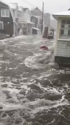
In Boston, the worst flooding is expected to occur during the high tide cycles near 11 am Friday and 11 pm Friday, when waves of 25 – 30 feet are possible just offshore. The NWS in Boston was giving a low (< 30 %) of major coastal flooding, but predicted at least moderate coastal flooding with significant beach erosion. If the Wednesday morning guidance from the GFS model comes true, though, the coast from Boston to central Maine will experience a top-five highest storm tide on record during three tidal cycles—late morning on Friday, late evening on Friday, and again late morning on Saturday. This stretch of coast is already struggling with tens of millions of dollars in damage wrought by the storm surge of Winter Storm Grayson on January 4, 2018. That storm brought a top-five highest storm tide on record to the coast from Boston to Central Maine, including the highest water levels ever recorded at Boston, Massachusetts and Bar Harbor, Maine (see video below of storm surge flooding from that storm in Scituate, Massachusetts, located 30 miles southeast of Boston).
No comments:
Post a Comment
Note: only a member of this blog may post a comment.