

This article from Robertscribbler bears out what I wrote yesterday about conditions in the seas arounf Australia and New Zealand at a time when we are supposed to be in a La Nina.
Predicted Record 94 Degree (F) November Temperatures for Dallas as Globe Warms Despite Trend Toward La Nina
1
November, 2017
The
globe should be cooling relative to recent and near record warm
summer temperatures. But it isn’t. La Nina like conditions, the
Pacific Ocean pattern that generally precipitates globally cooler
weather,
is again spreading across the Equatorial Pacific. Yet if you’re
living in Dallas, Texas, or many other places across the globe, you
wouldn’t know it.
For
this week, temperatures in Dallas are expected to exceed all previous
records since monitoring began back in 1898.
 (Record
warm temperatures predicted for Dallas later this week. Image
source: Euro Mode.)
(Record
warm temperatures predicted for Dallas later this week. Image
source: Euro Mode.)
According
to meteorologist Ryan Maue,
and to reanalysis of Euro weather model data, Dallas is expected to
see temperatures between 90 and 94 degrees Fahrenheit by Friday of
this week. Readings that would be considered pretty hot for a normal
summer day occurring on November 3rd. That’s really odd.
Especially
when you consider the fact that Dallas has never experienced a 90+
degree high temperature from October 31 through December 29 in all of
the past 119 years.
If
Dallas does hit 94 on Friday, that will be 21 degrees (F) above
typical high temperatures there for this time of year.
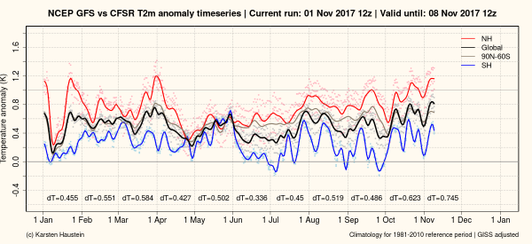 (According
to GFS Model Reanalysis, the globe has warmed through Northern
Hemisphere Fall despite a trend toward La Nina. Image source: Global
and Regional Climate Anomalies.)
(According
to GFS Model Reanalysis, the globe has warmed through Northern
Hemisphere Fall despite a trend toward La Nina. Image source: Global
and Regional Climate Anomalies.)
Drawing
back from focus on the Dallas region, we find that the world overall
is also warming relative to June through September temperature
departures. A climate change associated warming that appears to have
been kicked off, primarily, by warmer than normal temperatures at the
poles (see
previous article).
This despite cooling Equatorial Pacific Ocean surface waters
associated with a 55
to 65 percent of La Nina formation by winter.
In
a normal climate system, we would expect a trend toward La Nina to
produce relative cooling. But
this does not appear to be happening as
June warm temperature departures were lower than those during August
through October. Preliminary GFS reanalysis indicates that October
warm temperature departures were higher than those occurring in
September — likely hitting around 1.1 C above 1880s averages (see
image above).
So
despite a weak La Nina forming, it again appears that polar warming
is a major driver for global temperatures as fall moves into winter.
Climatologists take note.
Links:
No comments:
Post a Comment
Note: only a member of this blog may post a comment.