

State of Emergency declared in Timaru as rain lashes NZ causing widespread flooding
-
State
of Emergency declared in Timaru as rain lashes NZ causing widespread
flooding
-
Dunedin,
Timaru and Ashburton bore the brunt of the storm but there's more on
the way.
-
A
state of emergency was declared in the Timaru District at 3pm and
residents in flood-prone areas told to prepare for evacuation at
short notice.
-
NZ
Transport Agency is urging drivers to consider delaying journeys
south of Christchurch or north of Dunedin because of flooding.
-
Snow
is likely to low levels in areas from Canterbury to Southland
tonight

4.30pm: Emergency Management Otago has activated and is supporting Waitaki District and Dunedin City to deal with the impacts of heavy rainfall, flooding and strong winds.
Waitaki Civil Defence activated its own emergency operations centre at 3pm.
Group Controller Chris Hawker says at this stage Emergency Management Otago is monitoring and liaising with emergency services along the length of the Otago coast as well as the Otago Regional Council’s hazards team, who are monitoring river levels and modelling how they will react to rainfall.

"We are at a very early stage and we know from the forecast and modelling that there is a lot more rain to come over the next seven hours or so, particularly in Dunedin," Mr Hawker says.
He says many roads are affected by surface flooding, including the state highways along the coast and also inland. Further inland, snow is likely to become a factor as the temperatures drop overnight.
"While many people might have had travel plans this weekend, we would urge everyone to consider the conditions and think twice about hitting the roads tonight."
4.20pm: Timaru is under water.

River levels are expected to rise significantly over the next few hours. Any residents in flood-prone areas should prepare for evacuation at short notice. If you feel unsafe, evacuate immediately without waiting for notification.
Emergency services will be checking all at-risk areas and working to help evacuate any properties deemed at risk. All directions issued by emergency services personnel must be complied with.

A number of roads in low-lying areas are now closed and non-essential travel should be avoided.
For further information monitor the Timaru District Council website andFacebook page.
3.50pm: Cross winds are affecting flights at Queenstown Airport. Check flight info here.
3.40pm: Timaru has had a month's rain in eight hours.

In the last 8 hours, #Timaru has recorded more rain (46.4mm) than it typically receives in the entire month of July (43.7mm).@TimaruHerald
3.25pm: The NZ Transport Agency is urging drivers to consider delaying journeys south of Christchurch or north of Dunedin today. There's significant flooding on SH1 and local roads in South Canterbury and along SH1 Coastal Otago from Timaru to Dunedin.
3.20pm: Timaru District Council has told 1 NEWS a state of emergency has been declared in the district as of 3pm today.
Earlier this afternoon the Timaru Civil Defence Emergency operations centre advised all residents in flood prone areas to get everything they need together ready to evacuate their homes quickly.
EOC Controller Justin Bagust said that people in particularly flood prone areas should now be making preparations in case they have to evacuate at short notice.
“We would strongly advise people in these areas to get themselves prepared to leave as soon as they feel at risk, not to wait for any official notification," he said.
3.00pm: Heavy rain and wind is still buffeting Canterbury and Otago and surface flooding has been reported in some areas.
South Cantabrians are being warned to get ready to evacuate.
Significant surface flooding on the road between Christchurch to Ashburton this afternoon has NZTA asking motorists to delay travel if possible.

A number of roads in Christchurch and Banks Peninsula have been closed and Fire and Emergency southern says at least 25 properties have been affected by flooding in the region.
The worst affected have been in Ashburton, Rakaia and Rangiora.
In Otago, flooding has been reported at Kakanui and inland from Maheno.
2.20pm: MetService have released Road Snowfall Warnings for the far south.
2.15pm: MetService say thundery showers are set to continue through to this evening for the northern half of the North Island.
2.06pm: The Cadbury Jaffa Race and Steepest Street party in Dunedin has been postponed due to the bad weather.
Today's Cadbury Jaffa Race and Steepest Street party has been postponed today due to weather.#dunedinnz fb.me/6CZ06fQZS

1.53pm: Rainfall totals in Canterbury: 84mm in Methven, 79mm in Geraldine, 73mm in Ashburton, 70mm in Darfield, and 68mm in Akaroa this morning, according to MetService.
1.45pm: Emergency services and volunteers near Mokihinui, West Coast battled the winter storm to rescue an injured man from a difficult location this morning, Nelson, Marlborough, West Coast Police say.

Emergency services rescue of injured man on the West Coast.
Source: NZ Police

Emergency services rescue of injured man from remote West Coast location.
Source: NZ Police
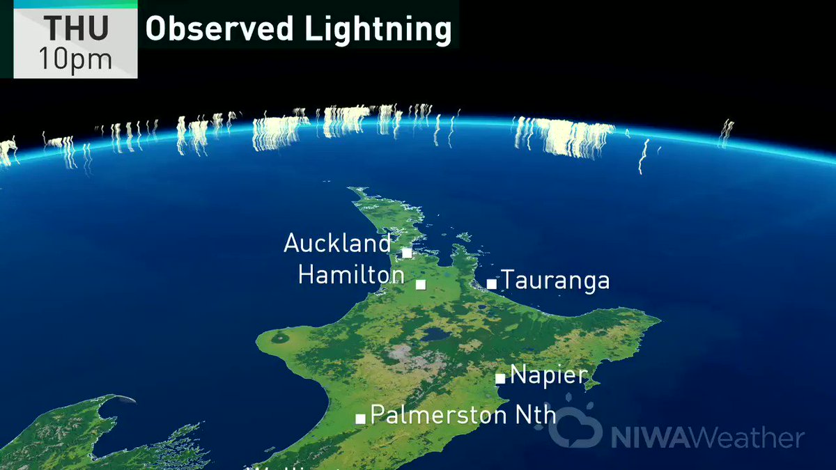
1.40pm: MetService say there's been 471 lightning strikes over the upper North Island.
1.30pm: Transport Christchurch are urging Ashburton and Christchurch locals to delay travel as flooding is causing delays.

1.27pm: Hail isn't the only thing battering Auckland today, as thunder and lightning struck the region overnight.
 near the North Island since last night...
1.21pm: For the latest road closures check the bottom of our live updates, and stay up-to-date here.
1.14pm NZTA say widespread flooding conditions are affecting highways across North and South Canterbury with heavy rain continuing. If you're driving in the region today make sure you slow down and take extra care they say,
Surface flooding is also affecting roads throughout Tasman, Marlborough, Kaikoura Coast.
1:08pm Timaru District Council is advising residents to make preparations to evacuate in places prone to flooding. "This is a quickly developing situation and people need to be ready to go. This means ensuring you have clothes and fuel, as well as things such as knowing where family pets are."
12:36pm Police are advising motorists in Mid and South Canterbury to drive with "extreme caution" due to flooding in Ashburton, Waitaki and Timaru and the high country. "Some roads in these areas many not be passable in 2WD vehicles."

Road users advised to slow down, drive with extreme care in wet and windy conditions: 12:00pm update. ^JPow.ly/E2bl30dNsKT
12:20pm Christchurch City Council is urging resident to avoid contact with water from the Avon and Heathcote Rivers and from Lyttelton and Akaroa harbours due to a risk of pollution. The council says contact should be avoided with these waterways until two days after the rain has stopped.
12:18pm Flood water is getting into the wastewater netrowk and causing overflows in areas across Christchurch and Banks Peninsula.
11:55am Southern Fire crews have received multiple call outs to flooding. The worst affected areas are Ashburton, Methven, Timarau and Rakaia. A spokesperson for Southern Fire told 1 NEWS they're on stand-by waiting for the rest of the bad weather to come. They want to reiterate they don't carry sand bags due to receiving a number of calls from concerned residents who are wanting to get their hands on some. People are urged to contact their local council regarding sand bags.

Surface flooding in Otaio SH1, South of Timaru.
Source: 1 NEWS
11:42am Aucklanders have taken to social media to share photos and video of hail that has lashed the city this morning.


11:41am The Inland Route in to Kaikoura (Waiau to Peketa) is currently closed due to multiple slips and rockfalls.

Route 70 Inland Kaikoura Rd (Waiau to Peketa) is currently closed due to multiple slips and rockfalls. ^JPow.ly/ykKu30dNqyC
11:37am Several roads have been affected by surface flooding in Marlborough. Taylor Pass Road south of Wither Road, New Renwick Road, Wairay Bar Road, SH 63 - West Coast Road, Inkerman Street and Marama Road are currently flooded.
11:30am The Ashburton District Council has issued a precautionary boil water notice for residents on the Montalto water scheme due to high rainfall levels. "Monitoring equipment at the Montalto treatment plant has detected high turbidity - otherwise described as murkiness - in the water supply." The precautionary notice will remain in place until further information is released from the council.
11:20am MetService has issued a road snowfall warning for Lewis Pass, Lindis Pass and Dunedin to Waitati Highway.
11:15am The storm currently battering the country is beginning to cause traffic chaos with slips blocking roads, and it's only expected to get worse.
Strong wind warnings have been issued for Bay of Plenty, Rotorua and Gisborne, with northwesterly gales gusting up to 120km/h in exposed places until about midnight.
Already a large tree has fallen on SH2 in Matata, in the Whakatane district between Mimiha Road and Pikowai Road, blocking both lanes of traffic.
On the same state highway, but in the Bay of Plenty, closer to Herepuru Stream a pohutakawa tree and slip are blocking a section of the road
In the South Island a slip is blocking one lane of SH6 between Nelson and Havelock.
And another further along SH6 on the Whangamoa Saddle near Lud River Bridge is blocking part of the road.
NZTA is advising drivers to take extra care.
In the capital Ngauranga station has been closed due to flooding, but Metlink Wellington say a shuttle bus is running instead.
Due to weather conditions in the Wellington region worsening Metlink also cancelled a ferry sailing from Days Bay.
No comments:
Post a Comment
Note: only a member of this blog may post a comment.