

Endless Hot Summer of 2016 — Heavy Arctic Sea Ice Losses, Record Temps for Alaska and Hermine’s Rains Barreling In
1
September, 2016
From
the Arctic leveling yet another challenge to all-time record lows for
sea ice, to a ridiculously long spate of hotter-than-normal
temperatures for Alaska, to Hermine — which appears to be readying
to drop 20 inches of rain over parts of the Southeast — there’s a
ton of concerning climate news today. Let’s get to it.
Storms,
Mega-Dipoles, and Shattered Sea Ice
A
few weeks ago, big
storms of near-record intensity started ripping through the Arctic.
These storms saw numerous pressure dips into the 960-millibar range.
These severe systems raked the ice with gale-force winds, heavy seas,
and rainfall. A vulnerable ‘arm’ of ice extending out from the
central Arctic toward Wrangel Island began to disintegrate under
these multiple insults.
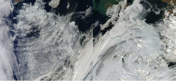
(The
two frames above provide a good visual of the most vulnerable Arctic
Ocean melt regions for early to mid-September. These primarily
compose the Siberian side of the Arctic and run on toward the Pole. A
mostly detached and storm-battered region of sea ice north of Wrangel
Island [left frame] is likely to see continued losses through
mid-September. At the same time, another vulnerable lobe of ice
extending from the Pole to the Laptev Sea [right frame] is seeing
substantial thinning. As southerly winds pick up later this week over
the Barents and Greenland Seas, the Atlantic side of the Arctic
[lower right portion of right-hand image] may also take a final blow
or two before refreeze starts to kick in. Images provided
by: LANCE-MODIS.
Date for images: September 1, 2016.)
Meanwhile,
another melting wedge running out from the Pole toward the Laptev Sea
was increasingly wracked, showing severe losses along the ice edge
even as large openings expanded, stretching in toward the Pole. As a
result, major late-season drops in Arctic sea ice area and extent
measures began to show. Unfortunately, the damage had only just
begun.
Last
week, this stormy pattern saw the added wrinkle of a strong
high-pressure system in the range of 1040 mb intensity forming over
the Chukchi and Beaufort Seas. This new system created an extreme
pressure gradient between itself and the storms raging near the Pole
and on the Atlantic side. Expert
Arctic sea ice observer Neven aptly coined this condition the 2016
Mega-Dipole.
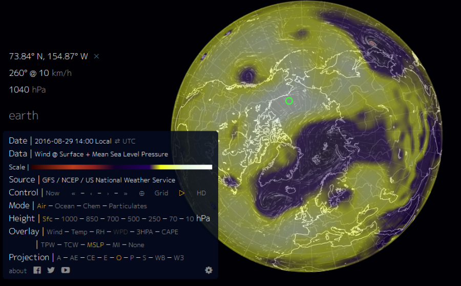
(Neven’s
Mega-Dipole featured
a burly high-pressure system over the Pacific side of the Arctic as
strong storms continued to rage across the Atlantic side on August
29th. The combined force of these systems helped further damage the
already weakened sea ice as warm winds blowing between them pulled
heat up from Siberia, generating a late-season temperature spike over
the Arctic Ocean. Image source: Earth
Nullschool.)
Strong
winds blew between the juxtaposed low- and high-pressure systems.
This convergence sucked an intense pulse of warm air up from the
south, not only providing a severe blow to the ice from gales and
waves, but also injecting a surge of late-season heat into the High
Arctic. In addition to the damage being done to the two melt arms,
the whole of the remaining contiguous ice was driven in one big push
toward the Canadian Arctic Archipelago — a shove that has now
likely resulted in the complete separation of the thinned
near-Wrangel ice from the pack even as large polynya (or
holes) opened
up within 10 kilometers of the Pole.
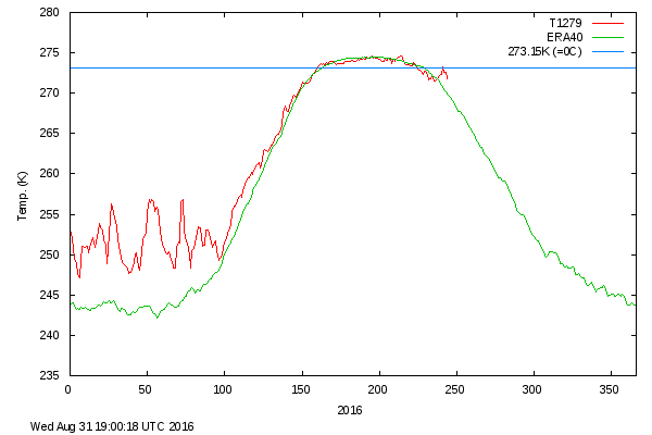
(A
late-season temperature spike in the region above 80° North Latitude
is helping to generate a surge in ice losses during early September.
Image source: DMI.)
All
this pushing and shoving and storming and low and high pressuring in
the context of never-before-seen Arctic warmth has brought most of
the major measures within range of beating out 2007 as second-lowest
extent on record by mid-September. Meanwhile, a few of the measures
are now making serious challenges to the 2012 record-low marks.
Over
the coming days, the various high-pressure systems are predicted to
shift more toward the Siberian side of the Arctic. Meanwhile, storms
are expected to gather around Greenland, with some hitting the 970 to
980 mb range as they circulate up from the North Atlantic. Warm air
is expected to funnel in from the Barents and Greenland Seas even as
the region north of Greenland starts a cooling trend.
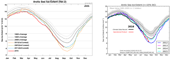
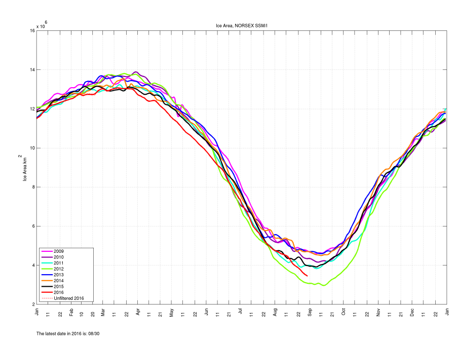
(Japan’s JAXA monitor
shows [top left] sea ice extent beating out 2007 in the daily extent
measure. Meanwhile, DMI’s
EUMETSAT-based
monitor shows [top right] extent falling to near the 2012 line. Sea
ice area in NERSC’s SSMI monitor
[bottom] over recent days comes uncomfortably close to the 2012
line.)
This
hot-cold juxtaposition combined with ongoing pressure from storms,
winds, and waves should continue to damage and expel the most
vulnerable sections of ice in the near-Pole region and on toward the
Laptev as well as the detached ice floes near Wrangel Island.
Additional losses in the range of 150,000 to 300,000 square
kilometers or more over the coming seven days are entirely possible.
If this happens, it would be a rather severe rate of loss for early
September all on top of a year that, on average so far, has seen
lowest-recorded sea ice extents for the January-to-August timeframe
and remains on track to hold that low mark through year-end.
An
Amazingly Hot Year for Alaska
We
should be very clear that despite all the storms and other weather
drama going on over the Arctic Ocean, the primary cause for severe
sea-ice losses is a record-hot world in which a lion’s share of the
temperature rise is occurring over the far northern latitudes. And
not too far from the melting Arctic sea ice, another Arctic region is
also getting a big dose of this record heat.
This
year, Alaska appears set to exceed all previous marks for warmest
temperatures ever recorded during an annual period for the state:
 Brian Brettschneider
Alaska with more days in the above normal tercile in 2016 that either 2014 or 2015 – the 2 warmest years on record.


(Through
August 27, Alaska had experienced zero cooler-than-typical days, 22
days of relatively normal temperatures, and 218 days in which
temperatures were in the top third of all daily averages. It’s a
record that makes previous all-time hot years 2014 and 2015 look
somewhat cool by comparison. Image source: Climatologist
Brian Brettschneider.)
As
climatologist Brian Brettschneider recently found, above, the number
of days featuring temperatures in the top third of measurements
included nearly nine out of ten of all days so far during 2016 and
through August 27th. This extreme Alaskan heat has already exceeded
the number of warmer-than-normal days during record-hot years 2014
and 2015. With four months in 2016 still remaining, and with the
Arctic Ocean opening up to its north, it appears that Alaska is about
to blow these previous record years out of the water.
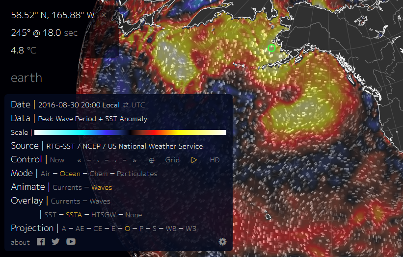
(Sea-surface
temperatures surrounding Alaska are between 3 and 5 degrees Celsius
above average. Such extreme ocean heat should help keep temperatures
abnormally warm over the state for at least the next couple of months
and continue to add to a period of record heat during 2016. Note that
the graphic above shows temperature departures from normal ranges,
not absolute temperature values. Image source: Earth
Nullschool.)
La
Niña is settling in, though. This would normally provide some hope
that temperatures in Alaska might start to fall off a bit, but right
now, the local ocean waters surrounding Alaska are extraordinarily
warm. It’s as if the Pacific ‘hot blob’ that plagued the U.S.
west coast in 2014 and 2015 has shifted north toward Alaska in 2016.
This climate change-related warm-water feature is likely to continue
to create a warm surface temperature bias for the state over the next
couple of months.
20
Inches of Rain Possible for Parts of the Southeast
Moving
south and away from the various heating and melting in the Arctic, we
find yet another big rainstorm brewing in the moisture-stacked
atmosphere of the Gulf of Mexico. In this case, unlike the big deluge
that roared through Louisiana during early August, this collection of
towering thunderheads has a name — Hermine.
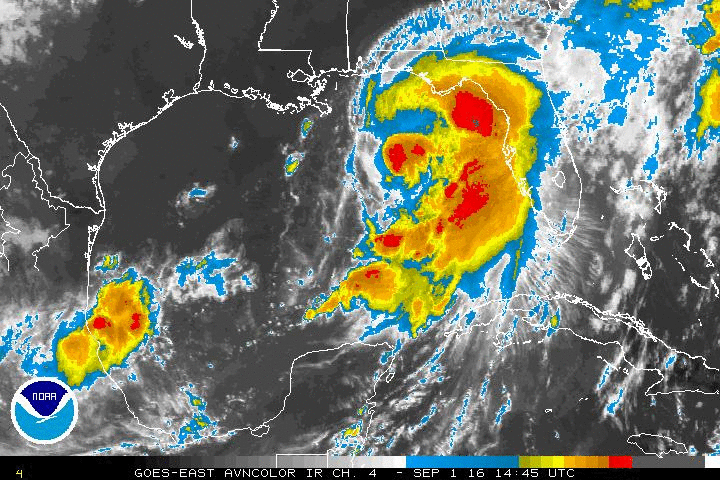
(Hermine,
which may produce severe flooding over the U.S. southeast in the
coming days, barrels toward Florida in this National
Hurricane Center satellite
animation.)
Punching
up to minimal hurricane status early in the afternoon (EST) on
Thursday, Hermine is predicted to make landfall along the big bend of
Florida (pushing in 3-8 foot storm surges), track north into Georgia
and then run up along coastal South Carolina, North Carolina and
Virginia. Along this path, 4-10 inches of rainfall are expected with
local amounts hitting as high as 20 inches.
Hermine is expected to produce storm total rainfall accumulations of 5 to 10 inches over portions of northwest Florida and southern Georgia through Friday, with possible isolated maximum amounts of 20 inches. On Friday and Saturday, Hermine is expected to produce totals of 4 to 8 inches with isolated maximum amounts of 10 inches possible across portions of eastern Georgia, South Carolina, and eastern North Carolina through Saturday. These rains may cause life-threatening flash flooding.
As
with past rain-bomb events this year, Hermine is churning through a
record-hot atmosphere and feeding on overall record-high moisture
levels. Sea-surface temperatures over the Gulf of Mexico and
particularly over the Gulf Stream region of the Atlantic near the
eastern seaboard are extraordinarily hot. Ocean surfaces off coastal
Virginia, for example, now rival those along the eastern Gulf at near
30 degrees Celsius (86 F). The result is that a ton of storm energy
in the form of heat and moisture is blanketing a big swath from
Florida to the U.S. northeast. In this heat- and moisture-rich
environment, even the high forecast rainfall amounts have a potential
to be exceeded.
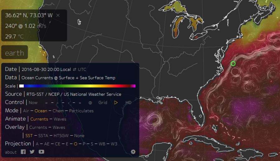
(Ocean
temperature and currents map for 8/30/16. Water temperatures in the
Gulf Stream off the U.S. east coast are near 30 C [86 F] or about 4 C
hotter than normal. This means there’s almost as much potential
storm fuel for a hurricane off the eastern seaboard as there is in
the northeastern Gulf of Mexico — fuel that can both provide energy
for extreme rainfall events related to Hermine and for a possible
rapid reintensification. Image source: Earth
Nullschool.)
Moreover,
Hermine is predicted retain a degree of strength over land due to
this fuel even as it is expected re-emerge over water along the North
Carolina sounds and then track toward the hot Gulf Stream. Along this
track, the storm is expected to restrengthen and lash coastal North
Carolina, Virginia, Delaware and New Jersey before it skirts Long
Island and Massachusetts. Given the hot ocean waters, some models
even show Hermine bombing into a significant storm with
ECMWF model runs earlier today highlighting a potential for a 969 mb
storm center off
Delaware on late Saturday.
Fortunately,
the storm center is currently predicted to remain offshore after
re-emerging over open waters on Saturday. However, the large
circulation of the system means that any reintensification will
likely see some of the storm’s related rain bands swirling out over
the mid-Atlantic and northeast coasts.
******
So
from big sea ice losses to record heat in Alaska, to what’s shaping
up to be another extreme rain event for the U.S. southeast, the
climate hits just keep on coming. It’s all a part of the context of
climate change that’s been steadily settling in over the past few
decades, which paints a rather obvious picture of ongoing climate
shifts and alterations to expected weather patterns — to include
the loss of sea ice, the intensity of heat over Alaska and the
severity of rains falling out during storms like Hermine.
Links:
Hat
tip to Colorado Bob
Hat
tip to DT Lange
Hat
tip to DavidlWindt
Hat
tip to Jay M
Hat
tip to the Arctic
Sea Ice Forum
Hat
tip to Greg
No comments:
Post a Comment
Note: only a member of this blog may post a comment.