

I have got to a point in my own personal exhaustion that I can no longer keep up with chronicling extreme weather events that are now almost daily events.
I
will leave it to Robertscribbler who does it so much better than I
can.
I
will either ignore or criticise nonsense such as "saving the
world" by voting for Killary Clinton
Hot Gulf of Mexico Hurls Rain Bombs at Florida and the U.S. Gulf Coast
8
August, 2016
Rain
bomb. It’s a new kind of severe rainstorm that’s capable of
overwhelming a city’s flood-handling capabilities in just an hour
or two. Of generating 2-inch-plus per hour rainfall events in odd
places and at unexpected times. A type of severe storm that’s been
enabled by all the added heat and atmospheric moisture loading
resulting from human-forced climate change.
*****
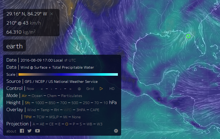
(High
levels of atmospheric water vapor over the northeastern Gulf of
Mexico is fueling the potential for severe, damaging and
life-threatening rainfall events across the Gulf Coast this week even
as numerous severe flood events occur across the globe. Image
source: Earth
Nullschool.)
Lately,
due in large part to an atmosphere and ocean surface that’s about
1.2 degrees Celsius hotter than 1880s values and related added
atmospheric moisture, the powerful, damaging, and life-threatening
rain bombs have been going off hard and heavy across the globe. Last
week, Ellicott
City was hit, killing one and generating damage that will likely take
years to repair.
Yesterday, about 21
people lost their lives in a freak flood that dumped 20 inches of
rain over part of Macedonia.
In Sudan on Saturday, the
Nile reached its highest levels in 100 years as thousands of homes
were destroyed and more than 75 people lost their lives.
In Karachi, Pakistan this weekend, 50
percent of the city is without power and ten people have lost their
lives due to flooding.
In India over the past two weeks, more
than one million people have been displaced and 100 killed in
devastating floods.
And now, a very hot Gulf of Mexico appears to be hurling a number of
similarly powerful storms at the U.S. Gulf Coast.
Severe
Gulf Rainstorms Begin
There’s
a hell of a lot of heat and moisture available to fuel storms over
the Gulf of Mexico right now. And this region where ocean surfaces
exceed 90 degrees Fahrenheit (running from 30 to 33 C, or 1 to 3 C
above average) over a broad swath is just now starting to toss some
extremely powerful rain bombs at nearby states.

(26
inches of rain fell over a portion of the Gulf of Mexico in one
24-hour period just west of northern Florida. Over the coming week,
this moisture is expected to shift northward over Lousiana,
Mississippi, and the Florida Panhandle. Image source: Jesse
Ferrell at Accuweather.)
Strong
convection is blowing up from the hot surface of these waters and
exploding into thunderstorms. Already, big rain bombs are starting to
fall out over the Gulf or streaming onto shore. As of yesterday, one
of these systems produced more than 26 inches of rain in just one
12-hour period. That’s an average of about 2.2 inches of rainfall
per hour for 12 hours running, an amount of water that would cause
extremely severe flooding if it fell on a U.S. city.
Today,
these rain bombs began roaring ashore over the Florida Panhandle. A
series of such systems dumped 20 inches of rain near Dekle Beach,
Florida even as powerful storms firing near Pinland and Perry dropped
16 inches.
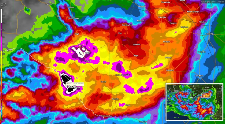
(Earlier
today, 20 inches of rain fell near Dekle Beach, Florida even as
totals near 16 inches fell between Pinland and Perry. Image
source: Jesse
Ferrell at Accuweather.)
To
be clear, these are just thunderstorms associated with a very hot and
moist weather pattern over the Gulf — but they’re producing
rainfall amounts usually seen in strong tropical cyclones.
Meanwhile, National
Weather Service radar shows
strong storms continuing to cycle into this region of Florida even as
south Florida is hammered by heavy storms and intense squalls swirl
over the western Panhandle, Alabama, and Mississippi.
More
Severe Rain on the Way, but the Rain Bombs Themselves are Tough to
Predict
Over
the coming week, the potential for continued heavy storms is
high. NOAA’s
precipitation forecast model shows rainfall potentials for the
region in
the range of 5-10 inches for some locations over the coming week.
It’s worth noting, however, that NOAA model runs have often not
captured the full potential peak rainfall totals in some recent
severe events. To this point, it’s also worth noting that
forecasting rain bombs can be difficult, particularly so during
recent years. Monitors like NOAA can track the underlying conditions,
but it’s generally tough to see exactly where the big precipitation
spike will occur until perhaps a few hours before the rain starts
falling.
Part
of this prediction difficulty is likely due to the fact that the
added atmospheric moisture loading — 8 percent since the 1880s and
5 percent since the late 1970s — due to global warming has
increased instability to the point where new, and less well
understood, types of weather are being generated. These days,
there are new kinds of thunderstorms ranging the globe, and there’s
a lot we don’t understand about them.
Links:
Hat
tip to TodaysGuestIs
Hat
tip to Andy in San Diego
No comments:
Post a Comment
Note: only a member of this blog may post a comment.