

Rapid Bombification — Super Typhoon Nepartak Barrels Toward Taiwan, Takes Aim at Already Flooded China
6 July, 2016
This year’s Asian monsoon has been a real beast for China. Inflated by the aftermath of a strong El Nino combining with record global temperatures, the system has sent powerful thunderstorms roaring over eastern sections of the Yangtze River Valley for the better part of two weeks.
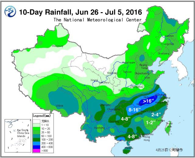
These storms have spurred record tornadoes, rocked the Chinese landscape with lightning strikes, and dumped more than 16 inches of rain over a region near Wuhan and just west of Shanghai. The powerful downpours and related winds have now resulted in more than 54,000 building collapses and an estimated 7.7 billion dollars in damages. 32 million people have already been impacted. 1.4 million people have been displaced. And 231 people are now dead or missing (see China Flooding).
(Very intense rainfall over the past two weeks over the Yangtze River Valley region of China has resulted in severe flooding that has destroyed 54,000 buildings and displaced 1.4 million people. Image source: China’s Meteorological Agency.)
And all this before the predicted arrival of a Super Typhoon which is expected to dump as much as 24 inches of additional rain near the hardest hit regions between Shanghai and Wuhan this weekend after it roars over Taiwan on Thursday.
175 mph Super Typhoon Nepartak in the Pipe
As China was reeling from the impacts of heavy rainfall, sea surface temperatures over the Northwestern Pacific were screaming hot. Surface waters over a region south and east of Taiwan on July 4 and 5 approached 31 degrees Celsius (88 degrees Fahrenheit) or 1-2 C above average. In addition, these hot waters extended to great depth beneath southeastern Pacific surface boundaries. As a result, the amount of ocean heat content available to fuel an intensifying Typhoon was at about the top range one would ever tend to see (near 150 KJ per square centimeter, according to Dr. Jeff Masters at Weather Underground).
Running through these deep, hot waters on July 4 was a 70 mph max wind intensity tropical storm Nepartak. But as wind shear lessened and Nepartak drew in a deep draught of that high energy Pacific Ocean heat and moisture, the storm exploded. In just one 24 hour period, the system added fully 80 mph of maximum wind speed intensity to leap from a mere tropical storm to a very strong category 4 Typhoon by Tuesday night.
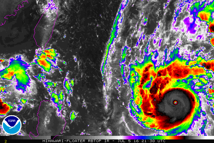
(Nepartak barrels toward Taiwan and China on Wednesday in this NOAA enhanced satellite image.)
By Wednesday, the storm had achieved category 5 Super Typhoon intensity with top sustained winds estimated at 175 mph and a lowest central pressure of 900 mb (Japanese Meteorological Agency andJoint Typhoon Warning Center).
The Typhoon is now expected to make landfall in Taiwan on Thursday as a Category 4 storm. Heavy storm surges, very powerful winds, and 5-15 inches of predicted rainfall over most of Taiwan with up to 43 inches in the higher elevations is expected to generate flooding, landslides, structural damage, and to disrupt crops.
The storm is then predicted to leap the Taiwan Strait and track north and west over mainland China. As the storm weakens, it is expected to be drawn northward into a trough that will ultimately funnel its moisture over the already flooded region between Shanghai and Wuhan. In this zone, between 4 and 24 inches of additional rainfall is possible as the storm winds down and unburdens its massive water load.
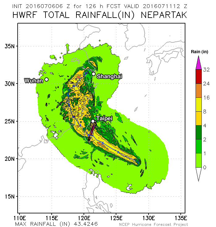
(NCEP’s predicted rainfall swath for Nepartak results in additional extreme rainfall expected for already flooded regions near the Yangtze River. Image source: NCEP and Weather Underground.)
In total, weather associated with Nepartak is expected to produce a 5 day long extreme wind, storm surge and rainfall event for Taiwan and China. Heaviest impacts will likely occur in Central Taiwan near the predicted point of landfall and in the region west of Shanghai where Nepartak’s predicted rains could result in even more severe flooding for the already hard hit Yangtze River region.
Conditions in Context — Ocean Heat Intensifying, Expanding in All Dimensions
A weak La Nina is starting to form in the Eastern Equatorial Pacific. And, already, deep, hot water formation has re-intensified in the Western Pacific. Ocean surfaces and temperatures at depth there are now very hot (1-2 C above normal at the surface, with such unusually warm waters extending well below the water-air boundary). Such hot, deep waters promote the formation of very intense tropical cyclones. During 2013, similar sea surface and deep water ocean heat states aided in the formation of the monster 190 mph Super Typhoon Haiyan which then devastated the Philippines.
These very hot water conditions occur in the context of a record warm world. And, in fact, scientific observation has found that not only are peak surface temperatures continuing to rise for broad ocean regions as heat expands into the depths, but that the size of biggest body of hot water on Earth in the Indian and Pacific Ocean is also getting bigger. This new world of hotter ocean surfaces, more extensive hot waters, and deeper extending warm waters all provide more storm intensifying fuel for powerful typhoons and hurricanes.
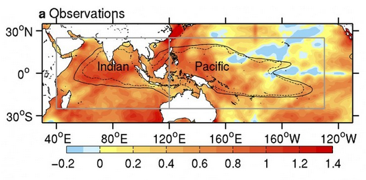
(The hottest pool of water on Earth lies in the Indian and Pacific Oceans. And, according to new scientific research, that hot pool is expanding in size due to human-forced climate change. Image source: Human-Caused Indo-Pacific Warm Pool Expansion.)
In addition, extreme rains over China have been fueled by a record atmospheric moisture loading. As global temperatures increase, the rate of evaporation also increases. This results in more water held aloft in the Earth atmosphere. Overall, atmospheric water vapor content increases by about 7 percent for each 1 degree Celsius of warming. And the result is an increased likelihood for extreme droughts in some regions (due to added heat and related increasing evaporation rates) and extreme rainfall in others (due to the extra atmospheric moisture producing more intense storms with heavier downpours).
So while the La Nina to El Nino cycle is helping to drive the location of extreme rainfall over China and the location of tropical cyclone formation in the Pacific, human-forced warming is providing more atmospheric fuel to increase the top potential strength of these events.
Links/Attribution/Statements
Scientific hat tip to Dr Jeff Masters
Hat tip to Greg
Hat tip to DT Lange
Hat tip to Colorado Bob
Hat tip to 65Karin
No comments:
Post a Comment
Note: only a member of this blog may post a comment.