

Monster Fort McMurray Fire Slowed Sunday by Light Rain — Despite Progress, Officials Expect Blaze to Burn for Months
“I’ve
never seen anything like this. No-one has ever seen anything like
this fire, the way it started, the way it spread, the way it
traveled. We will be rewriting the book on fighting these fires, this
fire will force us to rewrite the book”
*******
9
May, 2016
On
Saturday, the Fort McMurray fire rapidly expanded — threatening the
greenhouse gas emitting tar sands facilities north of town and making
a race toward the Saskatchewan border. But by Sunday, cooler
temperatures and very light rain in some areas (with accumulations of
less than 1 mm), helped to stymie what, until that time, was an
entirely uncontrollable blaze.
Fire’s
Northward Expansion Halted Before Tar Sands Facilities Were
Significantly Damaged
Fires
ran directly to the boundaries of the Nexen tar sands facility. But
heroic efforts by firefighters stopped the blaze there and prevented
all but minor damage to structures and to large vessels containing
volatile compounds. In total, the massive firefighting effort — now
undertaken by more than 500 personnel — was able to check the
northward advance of the flames on Saturday. By Sunday and Monday, a
shift in the winds toward the west and northwest again drove the
fires eastward.
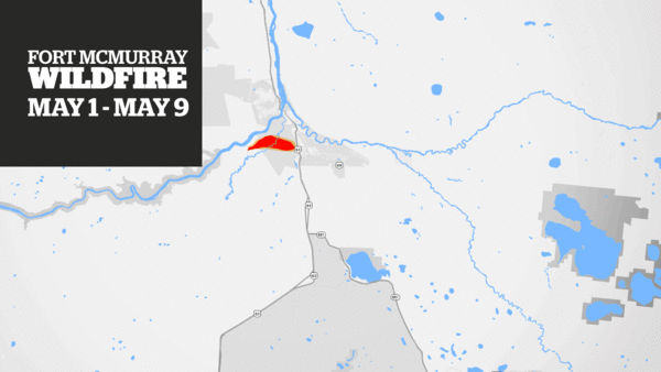
(The
Fort McMurray fire has grown to more than 16 times its original size.
Northwest winds continue to push its expansion toward the
Saskatchewan border. Cooler weather and very light rains helped slow
the fire Sunday. But with no rain in the forecast until May 23rd and
with more warm weather on the way, fire conditions may again worsen
this week and on into the next. Image source: CBC
News Live Updates.)
Current
active large fires near Fort McMurray are about 16 miles to the south
and west of town between the Athabasca River and Route 63, near the
shores of lake Gregorie, and across the Clearwater River just to the
north of the Fort McMurray airport. Though still somewhat
threatening, overall fire activity in the area is the lowest since
Tuesday of last week. Further to the east, large fires continue to
burn toward Saskatchewan and, with winds expected to blow off and on
out of the northwest over the coming 5 days, it’s likely that this
massive blaze will expand outside the borders of Alberta. To this
point, the fire edge is now less than 18 miles away from Saskatchewan
and winds are still blowing at moderate strength out of the
northwest.
The
Damage Assessment Begins — No Word on When 90,000 Climate Change
Refugees Can Go Home
Overall,
officials are reporting that 161,000 hectares have burned so far (or
about 620 square miles). Since Tuesday, the area consumed by the
flames had grown explosively to roughly 16 times the fire’s
original size. Cooler conditions this week should help to keep
explosive growth in check. However, by Thursday and Friday,
temperatures are again expected to warm — generating an increasing
fire hazard for later this week. In addition, weather forecasts call
for little to no chance of rain until May 23. So the region is
expected to continue to experience extraordinarily dry conditions —
conditions that helped contribute to the extreme fire hazard in the
first place.
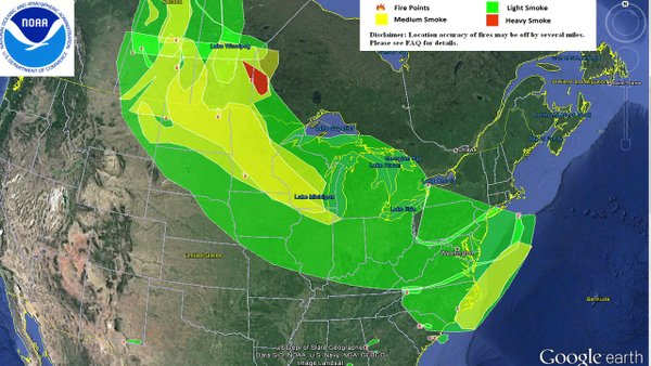
(The
vast Fort McMurray Fire has produced an immense smoke plume that has
traversed Canada, crossed the Northern and Central US and is now
entering the airs over the Atlantic Ocean off the US East Coast.
Image source: NOAA.)
Sunday
and Monday’s lull in the blaze has allowed officials to begin to
take stock of the extreme and extensive damage around Fort McMurray.
In addition to the 1,600 structures destroyed by the blaze, many,
many buildings were reported damaged. Fort McMurray’s electrical
system is completely knocked out — with emergency facilities
running on generator power. The city’s water supply — though
continuing to flow from the city’s still intact water treatment
plant — remains unsafe to drink. Officials will begin releasing
photos of the destruction over the next two days and have warned
of ‘dramatic
images.’ As
for the nearly 90,000 people made into climate change refugees by
this blaze, there is still no word on when they will be able to
return home. And considering such extensive damage and a still active
and dangerous fire ranging the region — that answer could be weeks
to months (find
out how to help the fire victims here).
Impacts
to Fort McMurray’s and Canada’s tar sands industry has been
notably substantial. In total, more than 1 million barrels per day of
oil production is now off line and is expected to remain so for about
a month — even if the blaze does not re-emerge to threaten tar
sands facilities. In addition, firefighting officials expect it to
take months to get this massive fire completely under control. Even
with the cooler conditions and very light rains Sunday and Monday,
intense hotspots and very strong fire fronts are still expanding
outward from the burn scar zone.
Widespread
Large Fires in the Upper Latitude Regions of the Northern Hemisphere
are Conditions Consistent with Human-Caused Climate Change
Conditions
consistent with human-forced climate change remain in effect for Fort
McMurray and for most of Northwestern Canada. In total, nearly 150
fires now rage throughout this Arctic country and in Alberta alone an
army of more than 1,500 firefighters are now battling 32 wildfires
including the Fort McMurry blaze. In British Columbia, 79 strongly
active wildfires have completely absorbed that region’s
firefighting resources. And on the Ontario-Manitoba border near
Winnipeg, a
fire exploding to 40,000 hectares has forced more than 125 people to
flee and sparked a massive firefighting effort as that blaze grew
four times in size since Friday.

(Another
very large fire — now 40,000 hectares in size — threatens the
region near Winnipeg. As of Monday, more than 125 people were forced
to evacuate due to the rapidly expanding blaze. Above we see this
fire along with hotspots as seen by the NASA-MODIS satellite sensor.
Image source: LANCE-MODIS.)
Around
the world, wildfires are now erupting in northern regions and
permafrost zones along the Mongolia-Russia border and in the area of
Lake Baikal — which has suffered from a decadal drought and very
severe warming. As May progresses into June, we can expect this fire
zone to creep northward — eventually involving much of the
permafrost zone itself. And, to this point, a
powerful Arctic heatwave will bring with it increasing risks of fire
to Alaska and the Northwest Territory as temperatures are expected to
rise up to 30 degrees F above average (into the upper 60s and lower
70s F) there later this week.
Overall,
human-forced climate change caused by fossil fuel burning greatly
increases the frequency and intensity of wildfires by spreading heat
and drought into regions where vegetation is unused to such
conditions. In Arctic countries like Canada, new fuels come from
thawing permafrost which forms a combustible peat-like layer and
creates conditions where the ground itself can burn. Such
heat and thaw has contributed to much larger wildfires which have
become ten times more prevalent in the Arctic since 1950 and as the
world has warmed by more than 1 C above 1880s averages.
Continuing to burn fossil fuels will further intensify these already
extreme conditions. One need not point out that this is the first
time an entire Canadian city has been forced to evacuate due to
wildfires. But with climate change starting to come into full force,
such instances are far more likely to happen again and again — not
just in Canada, but around the world.
Links:
Hat
Tip to Andy in San Diego
Hat
Tip to DT Lange
Hat
Tip to Cate
No comments:
Post a Comment
Note: only a member of this blog may post a comment.