

As I mentioned yesterday... the latest from Robertscribbler.
Warm North Pacific Winds Predicted to Usher in Brutal Arctic Heatwave this Week
8
May, 2016
Sprawling
over the Northeastern Pacific, there’s a big, doggedly-determined
high pressure system. One grown to enormous size and influence in a
global atmosphere boiling with the heat of fossil-fuel laden airs. A
weather system that’s now able to stretch out a long arm of
influence into the High Arctic due to an unrelenting northward shove
of oppressive record global heat.

(The
Beaufort Sea Ice has been shattered under
the weight of a relentless a high pressure system that
has dominated this region of the Arctic for about a month. Now, a
freak early-season invasion of above-freezing temperatures is set to
level another melt-forcing blow at a region that is very sensitive to
the worsening impacts of human-caused climate change. Image
source: LANCE-MODIS.)
Extreme
Fires, Sea Ice Loss in a Context of Ever-Worsening Climate Change
Beneath
the high, much warmer than normal airs have settled in over the
Northeast Pacific, over Western Canada, and over Alaska. These much
hotter than typical temperatures have provided fuel for a raging
start to fire season in such far northern regions. In Canada, nearly
a hundred and fifty fires now burn.
Sparked by never-before-seen heat and dryness, the worst of these
blazes has now consumed 620 square miles of land and more than 1,600
structures around the city of Fort McMurray — forcing about 90,000
people to evacuate and threatening Canada’s hothouse gas emitting
tar sands production facilities. Meanwhile, in Alaska, the heat has
been lighting off forest fires since as early as February. A month
that once only featured a climate of deep chill and heavy snow —
but one that in the new, greenhouse gas warmed, world features an
ominous winter burning.
The
high has also extended it atmospheric influence up into the Polar
zone — joining a powerful ridge that has torn away and shattered
sea ice across the Central Arctic since at least mid-April. Opening
wide areas of dark, heat absorbing water and contributing to
never-before-seen low levels of sea ice extent and volume for May.
May
Arctic Heatwave Builds
As
of Sunday, this lumbering high began a big shift to the west —
expanding its influence on into the North-Central Pacific and the
Bering Sea. There, it rallied a warm flood of airs in the form of
northbound winds. Warm winds now readying to make a big push into the
Arctic Ocean later this week.
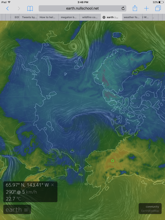
(Huge
northward thrust of warm air seen in this Earth Nullschool capture
for predicted May 12 conditions. Note the large swath of
above-freezing temperatures invading the Arctic Ocean as readings in
Northern Alaska and the Northwest Territory of Canada hit the upper
60s and lower 70s. Regions that are typically still covered in snow
experiencing conditions that would be somewhat warmer than normal May
weather for the US West Coast city of San Fransisco more than 2,000
miles to the south. Image source: Earth
Nullschool.)
These
winds are expected to build northward along a warm frontal zone over
Northern Alaska and the southern reaches of the Beaufort and Chukchi
Seas on Monday. Linking up with two low pressure systems forming over
the East Siberian Sea by Wednesday morning, this wave of heat rising
out of the Pacific is expected to have expanded into that sea and
taken in all of the Chukchi and half of the Beaufort. By Friday, this
northward drive of above freezing airs is expected to have taken in
about a third of the Arctic Ocean region in total.
Over
Alaska and the Northwest Territory near the Mackenzie Delta,
temperatures are expected to rise into the upper 60s to upper 70s
Fahrenheit (20-25 C). These are temperatures 20-28 degrees F (9-16 C)
above average for early-to-mid May and readings seldom seen for this
region even during June. Such high temperatures will hasten melt of
any remaining snow or ice and spike fire hazards over this Arctic
zone.

(Two
lows on the Siberian side of the Arctic and a high over southern
Alaska and the Northeast Pacific are predicted to drive an extreme
level of heat into the Arctic starting Monday and continuing on
through the end of this week. This extraordinary northward thrust of
warmth appears set to tip the scales swiftly toward high Arctic thaw
conditions that are typically experienced during June. Such a high
degree of added heat will have a profound effect on both sea ice and
remaining snow cover. Image source: Global
and Regional Climate Anomalies.)
Savaging
of the Sea Ice to Continue
Over
the Arctic Ocean, conditions will arguably be worse. Temperatures in
the near coastal waters of the Beaufort Sea could rise to as high as
41 degrees F (5 C) while temperatures in the range of 32-38 F (0 to 3
C) are expected to cover a very wide zone of Arctic waters invading
about 600 miles of the thinning sea ice area between the Mackenzie
Delta and the North Pole and covering a breadth of around 800 miles
from the Canadian Archipelago to the shores of the East Siberian Sea.
These temperatures are also 20-28 F (9-16 C) above average and are
more like the atmospheric readings one would expect during July over
these typically frozen Arctic waters.
It’s
not just the high temperatures that are a concern with this invasion
of extreme heat running into the Arctic. It’s also its sheer scale
— taking in about 30 percent of the Arctic Ocean zone, most of
Alaska, a large region of Northeast Siberia, and a big chunk of
Northwest Canada. Such a huge warm air injection will be taken in by
the larger circulation over the Arctic Ocean and greatly shrink the
remaining pool of cooler airs — driving temperatures to push more
rapidly above freezing.

(Off-the
charts record Arctic heat shows up in a -1012 freezing degree day
anomaly during 2016. In an average year, the Arctic experiences about
6,000 freezing degree days. We’ve lost more than 1/6th of that
during 2016, which is basically like knocking one month out of the
Polar Winter. Image source: CIRES.)
To
this point, temperature anomalies above the 66 North Latitude Line
are predicted to continue in the range of 2.5 to 3.5 C above average
for the entire Arctic region into mid-May during a time of year when
readings tend to moderate. In other words, this range is well above
average for this time of year and continues a trend of record Arctic
heat for 2016 that began during January. One that has now pushed
freezing degree days (FDD) to a never-before-seen -1012 anomaly —
which is like losing one entire month out of the coldest time of year
in the Arctic.
The
severe Arctic warmth continues to have a profound impact on Arctic
sea ice — pushing measures inexorably into new record low levels.
As of today, pretty
much all the major extent and volume measures showed sea ice at new
record daily lows and indicated a pace of melt at start of season
that is absolutely unprecedented.
Of particular concern are volume measures which have rapidly closed
and overcome the gap between previous record low years.

(DMI’s
sea ice volume measure enters a new record low range during early
May. Note how swiftly comparative sea ice levels have fallen since
February and March of this year. In essence, we are currently just
below the record low 2012 launching pad all while facing an
unprecedented level of heat building up in the Arctic. Image
source: DMI.)
In
this context of extreme Arctic heat and already record low Arctic sea
ice levels, we continue to expect new record lows to be reached by
the end of the melt season — pushing past one or more of the low
marks set during 2012 and possibly testing near zero sea ice ranges
(blue ocean event) of 80 percent volume loss since 1979 and below
750,000 square kilometers of sea ice area and 1.5 million square
kilometers of sea ice extent by September of this year.
Links:
No comments:
Post a Comment
Note: only a member of this blog may post a comment.