

Bermuda High No More — Global Warming Shoves North Atlantic Anticyclone Toward Azores
10
August, 2015
The
semi-permanent weather patterns are all out of whack.
The Aleutians Low has been shoved into Alaska and the Beaufort. The
Pacific California High has shifted north and west to dominate the
region previously claimed by the Aleutians Low. And the Bermuda High
— a feature famous for directing tropical cyclones northward along
the Atlantic Seaboard has packed its bags and fled north and east.
During
the late summers of more stable climates, a strong high pressure
system tended to form over the region of Bermuda. The high swept
warm, moist air up off the Atlantic Ocean and over the Eastern
Seaboard of the United States. The high was also a reliable governor
of the movements of tropical cyclones — with the position of the
high critical in determining whether these powerful summer storms
would make landfall or rocket out to sea.
But
this August, the Bermuda High is nowhere to be seen. Instead, it’s
shifted more toward mid and north Ocean — closer to the Azores and
the Flemish Cap.
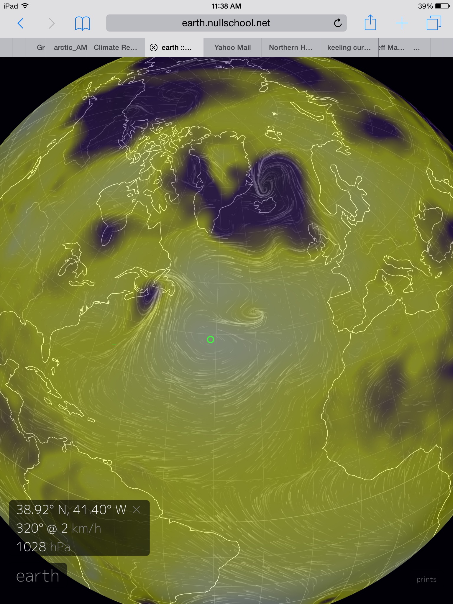
(The
Bermuda High can now also be counted among the growing number of
climate change refugees as it emigrates to the Azores and the higher
Latitudes of the North Atlantic. Image source: Earth
Nullschool.)
In
the above image, provided by Earth
Nullschool,
white denotes areas of high pressure and purple-to-red denotes areas
of low pressure. The green circle in the image marks the position of
the North Atlantic High in today’s GFS
summary map.
Note that the high is shifted more than 1,000 miles to the east and
north. It sits at the base of a ridge that stretches well north of
the Flemish Cap and then extends eastward to just south of Britain,
Scotland and Ireland. Near Iceland, a powerful cyclone rages. A
fickle storm that alternatively sets its sights along an arc from
England to Svalbard.
How
Human-Caused Warming Shoves the Bermuda High Northward
A
semi-permanent high pressure system north of the Azores and a very
stormy North Atlantic in the triangle between Greenland, Svalbard and
England is not remotely a normal summer weather pattern. It’s
instead a feature of a number of new ocean and atmospheric dynamics
that are the upshot of human-caused climate change.
As
equatorial heat embodied by the Hadley
Cell
expands outward from the lower Latitudes, the oceanic highs,
including the Bermuda High, are shoved northward. This motion tends
to also shift weather tracks into higher Latitude boundaries even as
it, at first, enhances waviness in the Jet Stream. Near North
America, we can see this dramatic weather alteration in the form of
the Ridiculously
Resilient Ridge over
the Pacific and the Terribly
Tenacious Trough over
the Eastern Seaboard.
A
second feature that influences the displacement of the North Atlantic
High is the expansion of a cool pool of water to the south and east
of Greenland. This cool pool is an upshot of the ongoing melt of the
Great Greenland ice sheet. As fresh water spills out from Greenland’s
glaciers it cuts off the northward propagation of the Gulf Stream
even as it prevents bottom water formation. This shutting down of
ocean circulation causes heat to build further south along the
Eastern Seaboard of the United States and in the Caribbean and Gulf
of Mexico. The lack of south to north heat transport combines with
the expanding fresh water cap to prevent ocean heat ventilation at
the surface in the North Atlantic. As a result, we see an expanding
pool of cool water in this zone. A signature feature of both human
caused climate change and of glacial melt in Greenland.
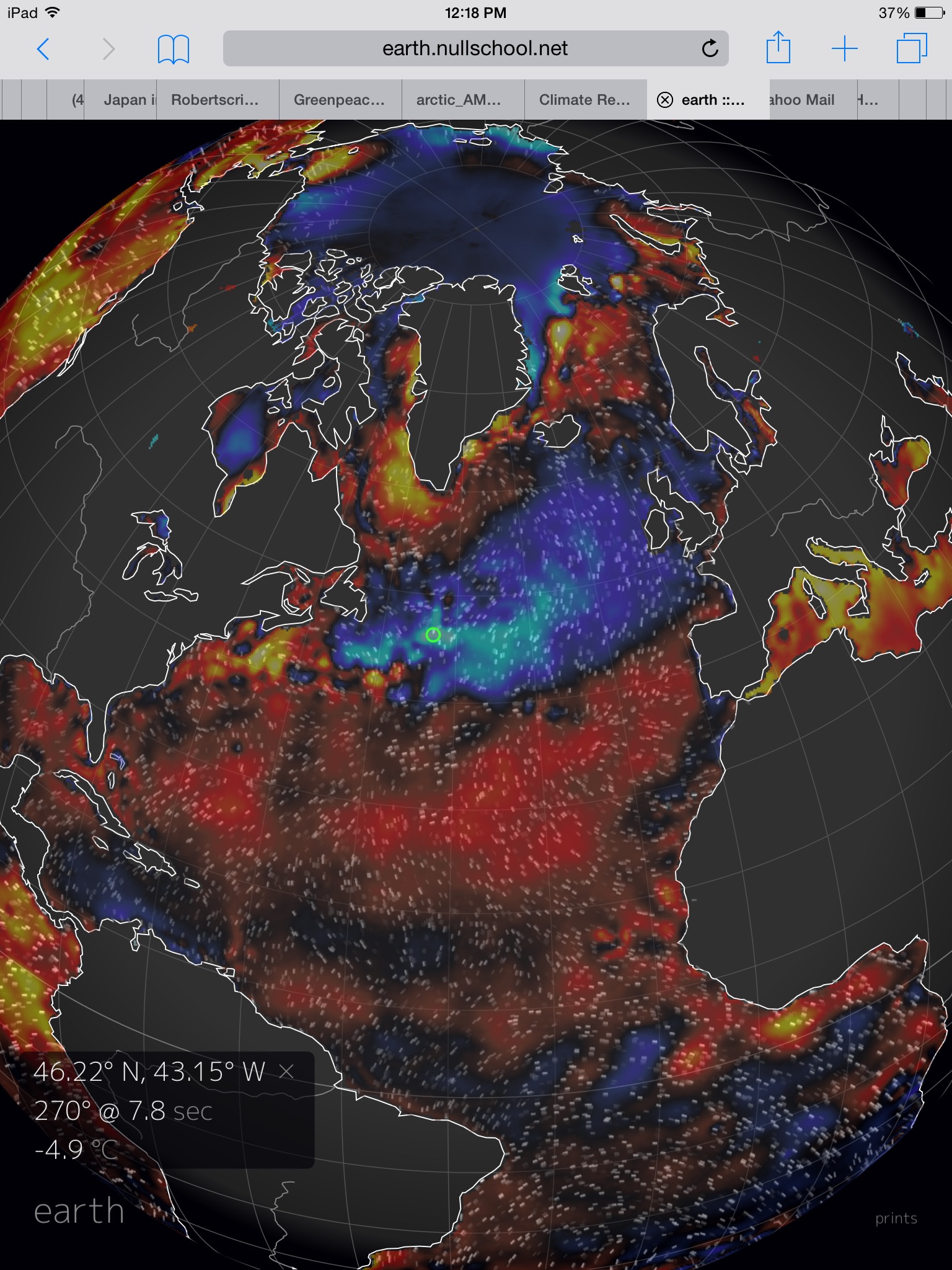
(Earth
Nullschool temperature anomaly map focused in on the North Atlantic
with near -5 C readings in an uncanny and freakish cool pool there.
This is the mirror opposite of the Hot Blob in the Northeast Pacific.
And, eerily enough, it is also a feature of overall global warming.
Image source: Earth
Nullschool.)
During
recent years, we have seen more and more of this cool pool formation
as both the Gulf Stream and bottom water formation in the North
Atlantic slowed down due to fresh water outflows from Greenland. It’s
an oceanic cool pool that forms a kind of atmospheric slot for the
Bermuda High to slip north through. It also generates an unstable
boundary zone between hot and cold waters and airs — a mechanism
that generates very high potential energies for powerful storms
cycling in a rough arc around Greenland (climate change driven storms
of this kind were the subject of a recent paper by Dr. James Hansen.)
As
glacial outflows from Greenland expand due to a continued forced
economic dependence on fossil fuels and the dumping of their toxic,
heat-trapping emissions into the atmosphere, we are likely to see the
Bermuda High continue to shift north. It’s the first of many
features that will tend to produce powerful atmospheric bomb-type
storms in a great zone within the North Atlantic. Storms of an
intensity we likely haven’t seen through all the 10,000 year period
of the Holocene.
It
is for this reason that the shift of the Bermuda High north and east
should be viewed as an ominous atmospheric move. One that is
preparatory to far worse weather to come — during a time when the
old Bermuda High will, perhaps, be viewed with a kind of fond
nostalgia. A gentler weather feature of a once far kinder climate.
Links:
No comments:
Post a Comment
Note: only a member of this blog may post a comment.