

Extensive Dark Snow, Very Large Melt Lakes Visible Over West Slope of Greenland as Late Season Melt Pulse Continues

(Image source: NSIDC)
A strong, late-season melt pulse continued over the Greenland ice sheet this
5
August, 2013
weekend as melt covered a much greater portion of the ice sheet
than is typical for this time of year. As of late July, the area of
the Greenland ice sheet subject to melt had spiked to nearly 45%.
Soon after, a second melt spike to around 38% followed. Over the past
two weeks, melt area coverage has fluctuated between 5 and 25
percentage points above the seasonal average for this time of year,
maintaining at or above the typical melt season maximum of around 25%
for almost all of this time.
This
late-season melt surge was driven by a switch in the polar Jet
Stream. A trough which had dominated through much of summer, bringing
near average temperatures and melt conditions, had eroded and by late
July a broad ridge began to form. This high amplitude wave dredged
warm air up from as far south as the south-eastern US, then dumped it
on the west facing coast of Greenland. There, last week, a new record
all time high temperature of 78.6 degrees (Fahrenheit) shattered
Greenland’s previous highest temperature of 77.9 degrees.
And
this record heat is beginning to have a very visible affect on the
ice. Aqua satellite passes this weekend recorded a visible darkening
of ice cover in the region most greatly impacted by high temperatures
last week. The snow and ice cover there has taken on a sooty
appearance with darker gray tendrils finding their way deep into the
ice pack. At the same time, large melt lakes expanded over the region
with some of these lakes measuring more than three kilometers
across.
In
this first Modis shot we see a broad region of darkened, melt-pond
speckled ice forming over a very large swath of Greenland’s western
ice sheet:
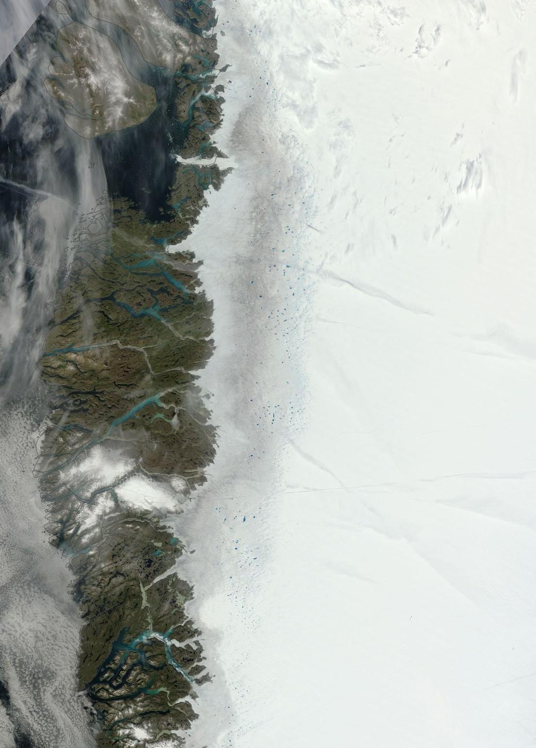
Greenland
west coast melt, August 4.
For
reference, Baffin Bay is toward the left of the image, the southern
tip of Greenland, toward the bottom, and the far right frame of the
image runs about down the center-line of the south Greenland ice
spur. Note the swatch of dark ice that appears much like dirty snow
running down western side of the ice sheet. This major melt region,
at its widest, appears to dive as much as 100 miles into the ice
sheet. Even at this level of resolution, we can see the large melt
lakes speckling the inland border of this darkened region.
Zooming
in to a region where melt appears to have penetrated deepest into the
ice pack, we find even more dramatic features.
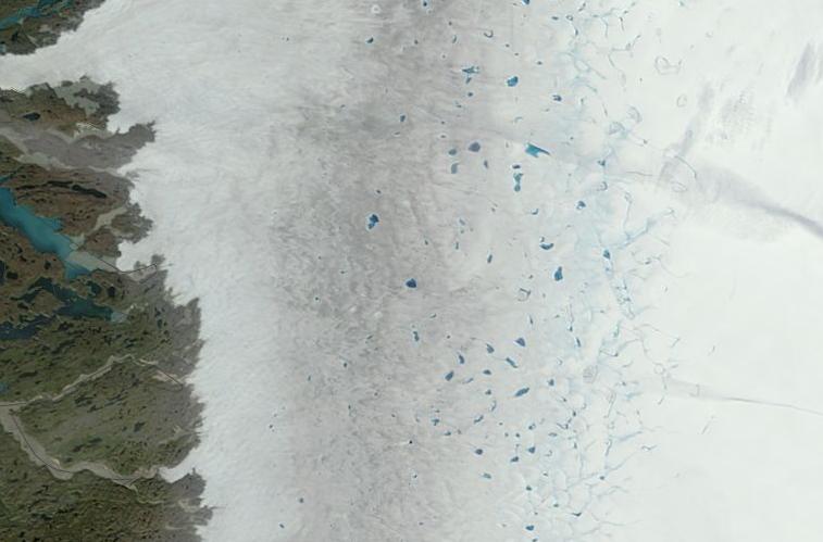
Greenland
melt lakes, dark snow, August 4, 2013.
The
orientation of this particular image is the same as the larger image
above, but we have just zoomed in to a large, central melt region.
Toward the coast, we can see melt and ice flowing into channels and
fjords. Adjacent to this rocky coastal zone is a region of more
rapidly mobile and fractured ice flows. Few melt ponds are visible in
this region and this is, likely, due to the large fissures and steep
vertical faces that cover most of the ice surface in this area. It is
beyond this boundary margin and inward toward the ice sheet’s
center that we find a second region of very dark snow and ice. This
area shows some large melt ponds, but its prominent feature is an
almost complete loss of reflective snow cover with lower layers of
soot deposition and darker sediment now exposed. Still further in, we
find the third, and arguably most dramatic, melt zone. This
particular area is coated, not in dark gray, but in blue. It is a
feature primarily caused by a very extensive surface melt covering
much of this region. In this single picture, we can count over a
hundred large melt lakes mostly dominating this region. They range in
size from about a half kilometer to over three kilometers across.
Connecting these lakes is what appears to be a web of melt rivers,
some of which terminate in moulins that core into the glacier’s
heart, delivering warm melt water the frigid ice’s center and base.
The general bluish color of this region indicates a very high degree
of melt with puddles and pools below the 250 meter resolution of this
particular satellite shot lending an azure tint to the ice.
Conditions
in Context
Over
the past two decades, Greenland has shown a very disturbing and rapid
melt response to human-caused warming. During the mid 1990s,
Greenland began to show a net loss of ice mass. Through the 2000s,
this melt rate accelerated, growing generally, but rapidly peaking in
rather disturbing melt surges as warm weather conditions grew more
extreme during certain years. By 2012, a very extreme melt year had
occurred, resulting in ice sheet losses on the order of 700 cubic
kilometers in just one year. These peak melt years appeared to re-cur
at a rate of once every 2-5 years even as overall average melt from
Greenland grew to a disturbing 500 cubic kilometers by the early
2010s.
Even
worse, sensors deep within the ice sheet indicated that the ice sheet
had become more mobile, increasing in velocity by about 2-3 percent
each year since 2010.
Though
2013 does not appear to be a peak melt year, as weather conditions
have favored less melt than in 2012, the continued softening of the
Greenland ice sheet remains a very disturbing summer feature. This
year’s west coast melt has been particularly dramatic, with the
most recent shots shown above featuring some of the worst melts I
have yet witnessed.
Links:
No comments:
Post a Comment
Note: only a member of this blog may post a comment.